Where We Work
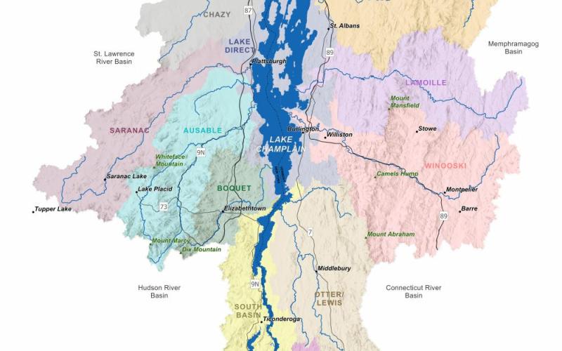
Lake Champlain Basin
The Lake Champlain watershed or basin encompasses 8,000 square miles of mountains, forests, farmlands and communities which all drain into Lake Champlain. The lake is 120 miles long, 400 feet deep and 12 miles across at its widest point. Outside of the Great Lakes, Lake Champlain is one of the largest freshwater bodies in the United States and is a highly valued international resource.

Many people who live in the Lake Champlain basin are dependent on the lake for jobs, recreation, and quality of life. People from around the world visit the lake and basin to enjoy its cultural and military history, abundant biological resources, and opportunities for recreation.
View a map of the Lake Champlain watershed and its tributaries provided by the Lake Champlain Basin Program.
Learn more about Indigenous stewardship in the Lake Champlain watershed from the video Nebi: Abenaki Ways of Knowing Water and about Indigenous lands from the Native Lands map, created by Native Land Digital, a Canadian not-for-profit organization.
Learn about Lake Champlain Sea Grant's mission, goals, and role in the basin.
Land Acknowledgment
The Lake Champlain basin is home of the Mohawk and Western Abenaki Peoples. Multiple Indigenous groups—including the Abenaki, Mohawk, and Mohican Peoples—steward and have stewarded these lands and waters for thousands of years. Lake Champlain Sea Grant respects Indigenous knowledge, commits to uplifting the Indigenous peoples and cultures in our communities, and acknowledges that we need to respect and steward the lands and waters in the Lake Champlain basin.